Property Record
Butner Rd, South Fulton, GA 30331

NEARBY LISTINGS FOR SALE OR LEASE
Property Detail
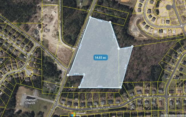
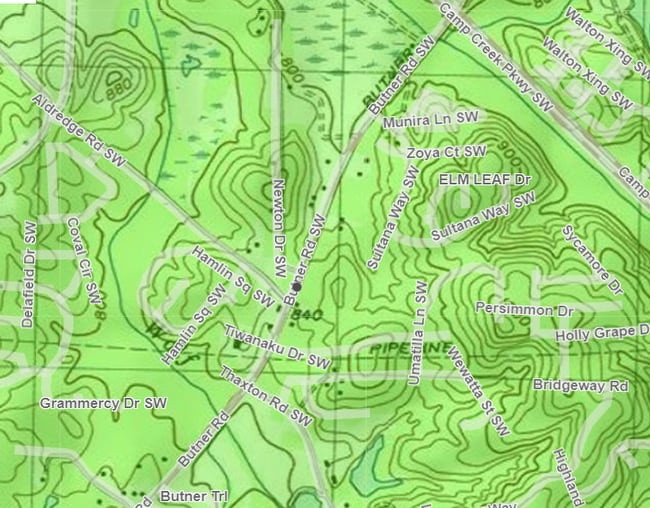
Butner Rd
14F-0072-LL-006-6
Fulton
Commercialacreage
Georgia
X
13.69 AC
13121C0341F
North Clayton/Airport
2024
Atlanta
2025
Atlanta-Sandy Springs-Roswell, GA
007810
DEMOGRAPHICS near Butner Rd
1 Mile
3 Mile
5 Mile
2024 Total Population
3,631
35,507
115,949
2029 Population
3,725
36,459
119,713
Pop Growth 2024-2029
+ 2.59%
+ 2.68%
+ 3.25%
Average Age
41
39
38
2024 Total Households
1,482
13,457
44,760
HH Growth 2024-2029
+ 1.62%
+ 2.59%
+ 3.26%
Median Household Inc
$101,786
$87,918
$73,008
Avg Household Size
2.40
2.60
2.50
2024 Avg HH Vehicles
2.00
2.00
2.00
Median Home Value
$316,314
$279,304
$261,813
Median Year Built
2005
2001
1997
Nearby Places
Map Layers
Map Styles
 Street
 Aerial
- Restaurants
- Banks
- Shops
- Fitness
- Groceries
PUBLIC TRANSPORTATION
AIRPORT
Hartsfield - Jackson Atlanta International
DRIVE
WALK
Distance
Hartsfield - Jackson Atlanta International
21 min
13.2 mi
Freight Ports
Georgia Ports - Savannah
DRIVE
WALK
Distance
Georgia Ports - Savannah
283 min
250.5 mi
SALE & LEASE HISTORY
LISTING DATE
SALE/LEASE

May 22, 2023
For Sale
Feb 01, 2021
For Sale
Apr 20, 2022
For Sale
Nearby Properties
Address
Land Use
TOTAL SIZE
Lot Size
Zoning
Address
Land Use
TOTAL SIZE
Lot Size
Zoning
11.10 AC
SUBC
Address
Land Use
TOTAL SIZE
Lot Size
Zoning
356,458 SF
18.72 AC
PDMU
Address
Land Use
TOTAL SIZE
Lot Size
Zoning
4,455,803 SF
16.39 AC
C2
Address
Land Use
TOTAL SIZE
Lot Size
Zoning
1,325,500 SF
101.81 AC
AG1
Address
Land Use
TOTAL SIZE
Lot Size
Zoning
6,069,632 SF
26.42 AC
R4
Address
Land Use
TOTAL SIZE
Lot Size
Zoning
330,838 SF
13.71 AC
PDMU
Address
Land Use
TOTAL SIZE
Lot Size
Zoning
1,052,500 SF
184.50 AC
AG1
Address
Land Use
TOTAL SIZE
Lot Size
Zoning
235,301 SF
27.20 AC
C2MC
Address
Land Use
TOTAL SIZE
Lot Size
Zoning
364,391 SF
25.33 AC
R4
Address
Land Use
TOTAL SIZE
Lot Size
Zoning
920,396 SF
62.40 AC
R3
Address
Land Use
TOTAL SIZE
Lot Size
Zoning
997,011 SF
68.07 AC
M1
Address
Land Use
TOTAL SIZE
Lot Size
Zoning
663,520 SF
62.96 AC
C1
Address
Land Use
TOTAL SIZE
Lot Size
Zoning
213,314 SF
16.48 AC
C2C
Address
Land Use
TOTAL SIZE
Lot Size
Zoning
274,956 SF
74.20 AC
AG1
Address
Land Use
TOTAL SIZE
Lot Size
Zoning
39.08 AC
SUBC
Address
Land Use
TOTAL SIZE
Lot Size
Zoning
42.90 AC
R4
Address
Land Use
TOTAL SIZE
Lot Size
Zoning
773,776 SF
61.42 AC
M1
Address
Land Use
TOTAL SIZE
Lot Size
Zoning
669,152 SF
39.13 AC
M1C
Address
Land Use
TOTAL SIZE
Lot Size
Zoning
546,520 SF
31.54 AC
M1C
Address
Land Use
TOTAL SIZE
Lot Size
Zoning
628,193 SF
56.10 AC
M1
Address
Land Use
TOTAL SIZE
Lot Size
Zoning
612,164 SF
34.83 AC
Address
Land Use
TOTAL SIZE
Lot Size
Zoning
5,238,150 SF
24.10 AC
R3C
Address
Land Use
TOTAL SIZE
Lot Size
Zoning
388,450 SF
34.75 AC
C1C
Address
Land Use
TOTAL SIZE
Lot Size
Zoning
426,244 SF
46.62 AC
AG1
Address
Land Use
TOTAL SIZE
Lot Size
Zoning
447,606 SF
26.68 AC
Address
Land Use
TOTAL SIZE
Lot Size
Zoning
116,305 SF
13.47 AC
C2
Address
Land Use
TOTAL SIZE
Lot Size
Zoning
102,976 SF
38.97 AC
AG1
Address
Land Use
TOTAL SIZE
Lot Size
Zoning
25.40 AC
AG1
Address
Land Use
TOTAL SIZE
Lot Size
Zoning
377,866 SF
23.50 AC
C1C
Address
Land Use
TOTAL SIZE
Lot Size
Zoning
354,966 SF
19.49 AC
C1C
The World's #1 Commercial Real Estate Marketplace
Connect with us
© 2026 CoStar Group
The information above has been obtained from sources believed reliable. While we do not doubt its accuracy we have not verified it and make no guarantee, warranty or representation about it. It is your responsibility to independently confirm its accuracy and completeness. Any projections, opinions, assumptions, or estimates used are for example only and do not represent the current or future performance of the property. The value of this transaction to you depends on tax and other factors which should be evaluated by your tax, financial, and legal advisors. You and your advisors should conduct a careful, independent investigation of the property to determine to your satisfaction the suitability of the property for your needs.